
Wednesday, July 18, 2012
Today, there have been a renewed series of small to moderate, mainly in the 3 mag range, just south of Mexicali, in Baja California. These quakes are all in one particular spot, and a few weeks ago, the same thing happened in the same area. This area is where the 7.2 mag 2010 Easter Earthquake happened. I have been feeling the ground move, lately. These little quakes are apparent, and there are a lot of them. I cannot place any meaning to them, but they are worth taking a look at to try and find the nature of them.
 The area is in the midst of a rifting zone, where the tectonic plates are pulling apart. It's an area of volcanism and frequent earthquakes. It is a part of the mid-pacific range, and extends up through eastern California.

Sunday, July 15, 2012
Wednesday, July 4, 2012
Monday, July 2, 2012
Today, and the day before, Mexicali has experienced a renewed swarm of earthquakes in the plus 4 point and plus 3 point magnitude. I feel that perhaps these just may be precursors to a larger seismic event. I could be completely wrong, and hope that I am - but this current swarm is worth considering, and worthing thinking about.
I implore that residents of the Southern Californian and Baja California Norte regions take pre-cautions and stock up on stored water and non-parishable foods.
Take a look at the earthquake map, and give this some thought and discussion among your friends. This may well be nothing, or something. I'm feeling the shaking, and it's pretty frequent. It's going on tonight and the house creaks now and then.

NOTE: This current swarm is more intense than the one before the 7.2 magnitude Easter Earthquake a couple of years ago.
I implore that residents of the Southern Californian and Baja California Norte regions take pre-cautions and stock up on stored water and non-parishable foods.
Take a look at the earthquake map, and give this some thought and discussion among your friends. This may well be nothing, or something. I'm feeling the shaking, and it's pretty frequent. It's going on tonight and the house creaks now and then.
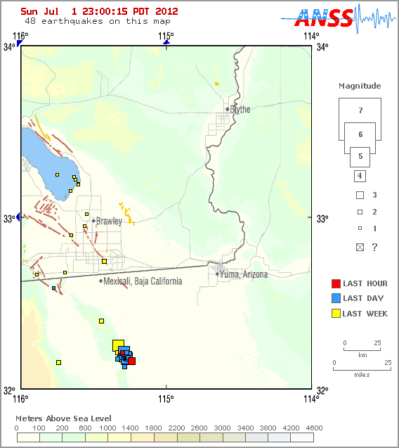
NOTE: This current swarm is more intense than the one before the 7.2 magnitude Easter Earthquake a couple of years ago.
Wednesday, June 27, 2012
Friday, June 15, 2012
Carolina Liechtenstein at Amboy Volcano
This is a trip I took out to Amboy volcano this last Sunday. I drove first to Palm Springs, CA to pick up a friend of mine, and then we drove along the old Route 66, which much of it is the Hwy 62 until you reach the town of Twenty Nine Palms. You then pick up the Amboy Road, and continue another fifty miles east and north. Once over Sheep Pass, there are no houses, ranches, gas stations....nothing.
If you go, you must carry a lot of water, a bit of non-parishable food, sat communications such as Spot, a first aid kit - and tell someone you love where are are going and for how long. I tell you, unless it's a weekend, there is nothing out there until you reach a town with two or three people in it! Oh yes and a chloride mine with a few people there.
In June, there were some European tourists on rented Harleys, for this is a favorite route for Europeans wanting to see the wildest of the wild west. Indeed.
The Amboy volcano is a part of the Mojave Young Volcano System, and is a part of the 7000 mile long Mid-Oceanic ridge that in theory extends from Vancover Island on down through the Sea of Cortez and beyond. This is within an area where the tectonic plates are pulling apart from one another, and this is a rifting zone.
In this blog, several times I have mentioned this rifting zone in the eastern part of California, and this video shows you what is very typical of rifting zones. You'll see plenty of basalt lava rock and signs of basalt magmas, just like in this video within rifting zones through out the world. Iceland has landscape like this, as does the Great Rift Valley of Africa.
So enjoy the video! I make it trippy and strange during the first minute or so, then dive into science. The music is mine and that of the Navajo band Lunar Drive.
http://youtu.be/btWM80_fAjA

If you go, you must carry a lot of water, a bit of non-parishable food, sat communications such as Spot, a first aid kit - and tell someone you love where are are going and for how long. I tell you, unless it's a weekend, there is nothing out there until you reach a town with two or three people in it! Oh yes and a chloride mine with a few people there.
In June, there were some European tourists on rented Harleys, for this is a favorite route for Europeans wanting to see the wildest of the wild west. Indeed.
The Amboy volcano is a part of the Mojave Young Volcano System, and is a part of the 7000 mile long Mid-Oceanic ridge that in theory extends from Vancover Island on down through the Sea of Cortez and beyond. This is within an area where the tectonic plates are pulling apart from one another, and this is a rifting zone.
In this blog, several times I have mentioned this rifting zone in the eastern part of California, and this video shows you what is very typical of rifting zones. You'll see plenty of basalt lava rock and signs of basalt magmas, just like in this video within rifting zones through out the world. Iceland has landscape like this, as does the Great Rift Valley of Africa.
So enjoy the video! I make it trippy and strange during the first minute or so, then dive into science. The music is mine and that of the Navajo band Lunar Drive.
http://youtu.be/btWM80_fAjA

Friday, June 8, 2012
New Quake Swarm at Salton Buttes Volcano in Southern Californa

Today, there has been a renewed series of small earthquakes at Salton Buttes Volcano, on the south end of the Salton Sea, in Imperial County near Niland, in Southern California. There is also a slight flurry of scattered micro-quakes though out the southern California desert region, included a pair of small EQ events at Covington Flats Volcano, just south of the Black Rock Canyon camp ground, near Yucca Valley, CA.


Here is the link to the current swarm at Salton Buttes Volcano, as well as a pair of EQ events at Covington Flat Volcano.

http://earthquake.usgs.gov/earthquakes/recenteqscanv/http://earthquake.usgs.gov/earthquakes/recenteqscanv/
Subscribe to:
Posts (Atom)