Tuesday, May 31, 2011

Update on Nine Week Long Earthquake Swarm in Nevada


Today there were some small earthquakes in the mountains just above Hawthorne, Nevada. But over the past few days, there had been many.


Here is a great and interesting conspiracy blog about the earthquake swarm in Nevada. There is indeed good info on these kinds of blogs, if you know what to look for and are discerning.


http://modernsurvivalblog.com/earthquakes/nevada-earthquake-swarm-precursor/


Now hard science. From the Reno Seismological Lab: Here are some views from a seismogram in Hawthorne, Nevada that show normal waveforms, not harmonic. These waveforms for the most part look like some cracking is going on, possibly creating new dykes and sills. Perhaps, but I have read and heard that the research community is still debating whether this is tectonic or volcanic in nature.


http://www.seismo.unr.edu/General?news=9


The above site is full of solid information on the frequency of the earthquake, categorized by magnitude and number of events. What should be noted is that this particular page, the one given above, states that there have been thousands of earthquakes near Hawthorne, Nevada below the magnitude of 1.

Saturday, May 21, 2011

End of the World, 158 Mile Deep Earthquake, Iceland Volcano


Humorously put: Right now I'm too busy blogging this and being a rock nerd to even pop my cork for some bubbly, bringing in the end of the world...


Just now we have two very interesting things going on as far as earth movements go, and right at a time, an hour ago (3 pm PST) when the world was supposed to end. Of course I'm mentioning the end of the world humorously, for who really knows if, how and when that will happen. But indeed, at 3 pm PST, there were crowds at Times Square, and an interesting deep quake and a volcanic eruption happened then.


We have had a 5.0 mag earthquake at the depth of 158 miles down. This is a complex and very deep subduction zone in the Banda Sea, north of Darwin, Australia. This is an are capable of very large earthquake because of a subduction zone, and where the plate is very deep and melting off some material, it kicks off some powerful and dangerous volcanos. These volcanos associated with the subduction zones in the area are usually of the explosive andesitic type, much like the famed and deadly Krakatau.


A subduction zone is an area where one plate, usually oceanic, crashes into another tectonic plate, and normally, because it's a thinner plate, it will bend downwards, and slide under the lighter thicker plate it has crashed into. The sinking plate dives into the semi-molton mantle below, and melts off some of the salt water bearing rock. That rock can turn into granite and andesite as it moves up through the mantle, and the crust.


In the picture here, with the colorful bands of dots, we can actually see the depths of the earthquakes in the past, those associated with this subduction zone.


You can see the more shallow quakes, where the orange dots are, which are 35 km deep to the surface. These tend to be the west most earthquakes. This is an area where the plate is not as deep.


The yellow dots are where the quakes a bit deeper, 70 to 35 miles down, and represent where the plate is deeper and grinding against the other plate and material there.


The green dots represents a depth of 150 to 70 km, and blue 300 to 150 km down. This is where the sinking plate is well into the hot mantle material below, causing a partial melt of both plate rock and mantle material.


We also see purple dots, representing earthquakes at 500 to 200 km down, and then a few red quake dots, those being 800 to 500 km down.


Look closely at the map, and look for chain islands and indicators of volcanism. I like to Google Earth this area too, to see the fantastic volcano chains in detail.


Krakatau is a volcano set between Sumatra and Java, and it is believed to be an area where sinking tectonic plates are twisted.


Here's a link on today's deep earthquake:


http://earthquake.usgs.gov/earthquakes/recenteqsww/Quakes/usc0003kwv.php#details


Also, in south eastern Iceland, a very active volcano started erupting just at the supposed end of the world was due to happen. It is in an uninhabited part of Iceland, and a large plume already has been seen and photographed. It just blew about an hour ago as of this writing, 4 pm PST. It probably won't do much more than send ash into the air, and probably won't cause extensive air traffic problems, judging by the past behavior of the volcano. This volcano erupted in 2004. Right now there are earthquakes associated with that volcano too. Here's a link to the first news reports on that event:


http://www.abc.net.au/news/stories/2011/05/22/3223393.htm?section=world

Thursday, May 19, 2011

The other night, I watched Emmerich's epic world demise flick, 2012. When thinking on the geology of the movie, a bunch of head scratchings and question marks popped up. The movie was a bit obscure on the geology involved in a potential world end. But it did indeed address odd surface earthquakes, which is what is going on right now near Hawthorne, Nevada.


Ok, I must also admit, I did get a kick out of the conspiracy theory in the film, that of of saving the billionaire white trash. Now that was funny and also sad for me, for I am well aware of an existing system to save the worlds top heap, if and when the you-know-what-hits the fan.


2012 is a fun movie to watch when you are stone drunk with a hyperactive seismogram going bonkers next to you....


Ok, just a bit of fun there, now let's go back to geology.


Before I update you on the quake swarm near Hawthorne, Nevada, let me share with you a link on a volcanic eruption in Japan. Check this activity out:


http://insidejapantours.com/japan-news/1889/jma-raises-volcanic-alert-on-mount-aso/


Here's a great blog going on about it, with great and informative links! Plus more links.


http://highboldtage.wordpress.com/2011/04/13/new-earthquake-swarm-hits-hawthorne-nevada-april-13-2011/


http://yubanet.com/regional/Swarm-of-400-quakes-hits-near-Hawthorne-Nev-outpaces-2008-Mogul-Somersett.php


http://www.syzygyjob.com/smf/index.php?PHPSESSID=0a29fce2031bfd6694f541bfa8de8e59&topic=259703.0


http://www.rgj.com/article/20110415/NEWS07/110415022/1459/news50/Six-earthquakes-jolt-Hawthorne-area-today-seismological-lab-sending-equipment-focus-quakes


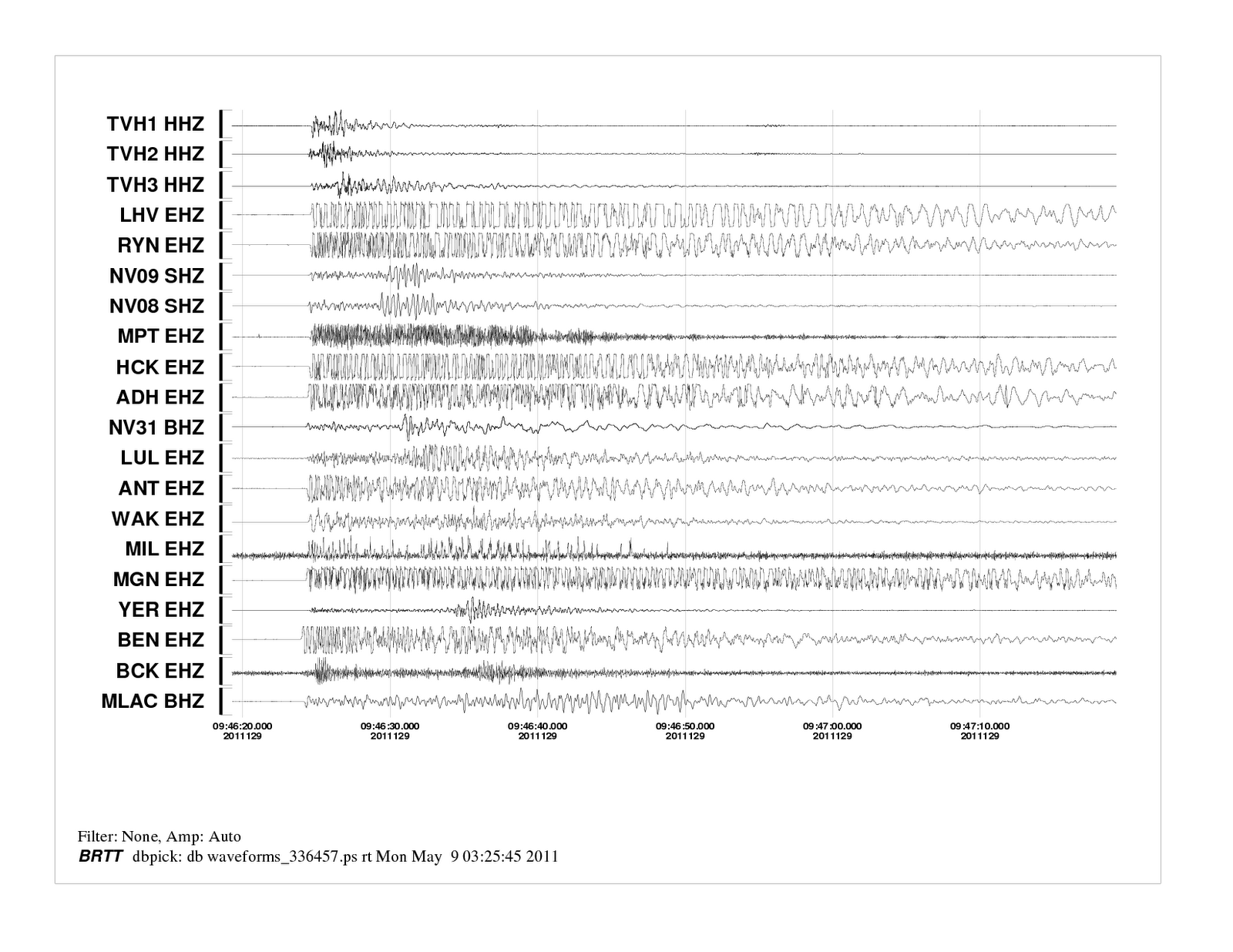
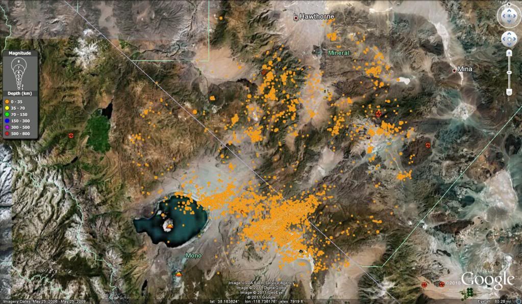
Here is a list of earthquakes in the Hawthorne, Nevada area as of April 27. Now remember that these earthquakes are still going on as of this writing on May 19, 2011. And below that is a thread post from someone with a bit of knowledge, somebody named Tom in Hollister, Ca. The info below is in the links I provided.


Earthquake list for map centered at 38°N,119°W


Update time = Wed, 27 Apr 2011 19:51:32 UTC


108 earthquakes in list

Mag Date

y/m/d Local Time

h:m:s Latitude

deg Longitude

deg Depth

km Location

1.9 2011/04/27 12:45:05 38.416N 118.725W 0.0 15 km ( 9 mi) SW of Hawthorne, NV

4.3 2011/04/27 12:19:20 38.414N 118.718W 2.6 15 km ( 9 mi) SW of Hawthorne, NV

1.4 2011/04/27 12:14:52 38.414N 118.712W 4.3 15 km ( 9 mi) SSW of Hawthorne, NV

1.0 2011/04/27 11:02:45 38.408N 118.730W 3.4 16 km (10 mi) SW of Hawthorne, NV

1.0 2011/04/27 08:34:00 38.820N 119.685W 2.7 9 km ( 6 mi) SSE of Gardnerville Ranchos, NV

2.1 2011/04/27 06:56:29 38.414N 118.719W 0.0 15 km ( 9 mi) SW of Hawthorne, NV

2.2 2011/04/27 06:26:29 38.410N 118.727W 0.3 16 km (10 mi) SW of Hawthorne, NV

3.5 2011/04/27 06:23:35 38.409N 118.726W 0.7 16 km (10 mi) SW of Hawthorne, NV

1.0 2011/04/27 05:35:31 37.547N 118.828W 7.7 13 km ( 8 mi) W of Toms Place, CA

1.5 2011/04/26 21:06:46 38.547N 119.500W 5.4 30 km (19 mi) ESE of Markleeville, CA

1.4 2011/04/26 11:51:23 38.421N 118.745W 1.9 16 km (10 mi) SW of Hawthorne, NV

2.6 2011/04/26 05:10:05 38.422N 118.718W 0.0 14 km ( 9 mi) SW of Hawthorne, NV

1.6 2011/04/26 03:40:11 38.420N 118.749W 3.0 16 km (10 mi) SW of Hawthorne, NV

1.5 2011/04/26 03:33:29 38.418N 118.747W 1.1 16 km (10 mi) SW of Hawthorne, NV

1.8 2011/04/26 02:26:19 38.377N 118.759W 1.7 20 km (13 mi) SW of Hawthorne, NV

1.8 2011/04/26 01:07:36 38.418N 118.715W 0.0 14 km ( 9 mi) SW of Hawthorne, NV

1.5 2011/04/25 21:44:51 37.895N 118.466W 10.6 42 km (26 mi) NNE of Toms Place, CA

1.7 2011/04/25 21:17:32 38.434N 118.739W 2.9 14 km ( 9 mi) SW of Hawthorne, NV

1.4 2011/04/25 18:23:37 38.431N 118.734W 3.7 14 km ( 9 mi) SW of Hawthorne, NV

1.3 2011/04/25 18:23:06 38.429N 118.736W 4.1 14 km ( 9 mi) SW of Hawthorne, NV

1.8 2011/04/25 16:42:01 38.416N 118.709W 5.2 14 km ( 9 mi) SSW of Hawthorne, NV

1.4 2011/04/25 14:49:56 38.455N 118.704W 5.6 10 km ( 7 mi) SW of Hawthorne, NV

1.7 2011/04/25 14:30:31 38.424N 118.740W 5.6 15 km ( 9 mi) SW of Hawthorne, NV

1.7 2011/04/25 12:33:48 38.411N 118.734W 4.4 16 km (10 mi) SW of Hawthorne, NV

1.9 2011/04/25 09:44:15 38.412N 118.719W 2.6 15 km ( 9 mi) SW of Hawthorne, NV

2.7 2011/04/25 09:32:47 38.413N 118.720W 0.0 15 km ( 9 mi) SW of Hawthorne, NV

2.1 2011/04/25 09:27:45 38.414N 118.717W 4.9 15 km ( 9 mi) SW of Hawthorne, NV

1.5 2011/04/25 08:14:21 38.385N 118.783W 0.0 21 km (13 mi) SW of Hawthorne, NV

1.9 2011/04/25 07:56:03 38.423N 118.735W 5.5 15 km ( 9 mi) SW of Hawthorne, NV

1.5 2011/04/25 04:08:13 38.420N 118.727W 0.6 15 km ( 9 mi) SW of Hawthorne, NV

1.6 2011/04/25 02:55:29 38.952N 118.295W 2.1 11 km ( 7 mi) SE of Rawhide, NV

1.4 2011/04/25 01:24:39 38.409N 118.749W 4.4 17 km (11 mi) SW of Hawthorne, NV

1.4 2011/04/25 00:13:04 38.746N 119.600W 6.7 18 km (11 mi) ENE of Markleeville, CA

1.4 2011/04/24 23:45:20 38.421N 118.742W 6.0 16 km (10 mi) SW of Hawthorne, NV

1.0 2011/04/24 23:28:27 38.395N 118.701W 6.3 16 km (10 mi) SSW of Hawthorne, NV

1.1 2011/04/24 22:55:36 38.380N 118.749W 6.2 19 km (12 mi) SW of Hawthorne, NV

1.2 2011/04/24 22:52:54 38.370N 118.753W 5.1 21 km (13 mi) SSW of Hawthorne, NV

1.5 2011/04/24 20:45:10 38.406N 118.698W 0.0 15 km ( 9 mi) SSW of Hawthorne, NV

1.0 2011/04/24 20:44:55 37.498N 118.579W 9.6 9 km ( 6 mi) N of Round Valley, CA

1.8 2011/04/24 19:27:07 38.415N 118.736W 5.6 16 km (10 mi) SW of Hawthorne, NV

1.8 2011/04/24 19:09:30 38.343N 118.784W 5.2 23 km (14 mi) W of Qualeys Camp, NV

2.0 2011/04/24 17:48:00 38.419N 118.743W 5.3 16 km (10 mi) SW of Hawthorne, NV

1.5 2011/04/24 17:45:53 38.438N 118.810W 0.1 19 km (12 mi) WSW of Hawthorne, NV

2.9 2011/04/24 17:32:50 38.420N 118.742W 3.5 16 km (10 mi) SW of Hawthorne, NV

2.7 2011/04/24 17:30:24 38.418N 118.745W 2.5 16 km (10 mi) SW of Hawthorne, NV

1.8 2011/04/24 17:25:32 38.420N 118.742W 7.0 16 km (10 mi) SW of Hawthorne, NV

1.3 2011/04/24 17:21:47 38.419N 118.742W 5.9 16 km (10 mi) SW of Hawthorne, NV

3.3 2011/04/24 17:03:21 38.411N 118.725W 0.4 15 km (10 mi) SW of Hawthorne, NV

1.8 2011/04/24 16:12:15 38.071N 118.920W 1.9 18 km (11 mi) SSE of Bodie, CA

2.4 2011/04/24 15:05:37 38.396N 118.771W 1.7 19 km (12 mi) SW of Hawthorne, NV

1.0 2011/04/24 14:56:22 38.385N 118.742W 3.2 19 km (12 mi) SSW of Hawthorne, NV

1.8 2011/04/24 12:26:24 38.427N 118.713W 6.1 13 km ( 8 mi) SW of Hawthorne, NV

1.5 2011/04/24 03:50:55 38.060N 118.941W 2.0 18 km (11 mi) SSE of Bodie, CA

1.4 2011/04/24 03:43:59 38.062N 118.939W 1.9 18 km (11 mi) SSE of Bodie, CA

1.0 2011/04/24 01:54:14 38.419N 118.719W 5.8 15 km ( 9 mi) SW of Hawthorne, NV

1.7 2011/04/24 00:47:08 38.429N 118.744W 0.5 15 km ( 9 mi) SW of Hawthorne, NV

1.9 2011/04/24 00:43:14 38.434N 118.714W 3.0 13 km ( 8 mi) SW of Hawthorne, NV

1.3 2011/04/23 23:54:51 38.410N 118.754W 5.1 17 km (11 mi) SW of Hawthorne, NV

1.4 2011/04/23 21:37:36 38.425N 118.727W 4.9 14 km ( 9 mi) SW of Hawthorne, NV

1.2 2011/04/23 20:32:27 38.410N 118.674W 8.6 14 km ( 8 mi) SSW of Hawthorne, NV

1.9 2011/04/23 19:59:03 38.422N 118.737W 5.6 15 km ( 9 mi) SW of Hawthorne, NV

1.7 2011/04/23 19:38:47 38.073N 118.929W 1.9 17 km (11 mi) SSE of Bodie, CA

3.5 2011/04/23 19:30:26 38.420N 118.717W 2.0 14 km ( 9 mi) SW of Hawthorne, NV

1.3 2011/04/23 18:44:18 37.590N 118.874W 2.3 11 km ( 7 mi) ESE of Mammoth Lakes, CA

2.0 2011/04/23 17:23:25 38.410N 118.716W 5.3 15 km ( 9 mi) SSW of Hawthorne, NV

1.8 2011/04/23 17:03:00 38.418N 118.739W 5.5 16 km (10 mi) SW of Hawthorne, NV

1.0 2011/04/23 14:12:25 37.481N 118.770W 17.0 12 km ( 7 mi) SW of Toms Place, CA

1.1 2011/04/23 13:36:22 37.630N 119.372W 7.9 22 km (14 mi) SE of Yosemite Valley, CA

1.5 2011/04/23 05:04:07 37.437N 119.039W 6.3 23 km (14 mi) SSW of Mammoth Lakes, CA

1.5 2011/04/23 04:59:43 37.456N 118.359W 6.4 11 km ( 7 mi) NNE of Bishop, CA

1.2 2011/04/23 03:02:37 37.532N 118.432W 8.7 19 km (12 mi) N of Bishop, CA

1.2 2011/04/23 02:44:59 38.053N 118.984W 1.3 16 km (10 mi) NE of Lee Vining, CA

1.3 2011/04/23 02:18:33 38.054N 118.924W 2.8 19 km (12 mi) SSE of Bodie, CA

2.0 2011/04/23 02:16:33 38.081N 118.932W 4.2 16 km (10 mi) SSE of Bodie, CA

1.5 2011/04/22 23:27:48 37.635N 118.882W 1.9 9 km ( 5 mi) E of Mammoth Lakes, CA

1.5 2011/04/22 22:17:50 37.535N 118.805W 13.3 11 km ( 7 mi) WSW of Toms Place, CA

2.4 2011/04/22 22:14:58 37.535N 118.805W 13.4 11 km ( 7 mi) WSW of Toms Place, CA

2.2 2011/04/22 17:39:33 37.639N 118.889W 1.6 8 km ( 5 mi) E of Mammoth Lakes, CA

1.7 2011/04/22 12:10:11 38.092N 118.916W 6.9 16 km (10 mi) SSE of Bodie, CA

1.5 2011/04/22 11:59:04 38.419N 118.732W 5.5 15 km ( 9 mi) SW of Hawthorne, NV

1.8 2011/04/22 11:36:08 38.073N 118.931W 1.6 17 km (11 mi) SSE of Bodie, CA

2.4 2011/04/22 11:28:34 38.081N 118.929W 5.2 16 km (10 mi) SSE of Bodie, CA

1.7 2011/04/22 09:01:09 38.079N 118.933W 3.6 16 km (10 mi) SSE of Bodie, CA

2.0 2011/04/22 08:47:28 38.077N 118.935W 4.0 16 km (10 mi) SSE of Bodie, CA

1.5 2011/04/22 08:46:17 38.080N 118.933W 3.1 16 km (10 mi) SSE of Bodie, CA

1.3 2011/04/22 06:33:24 38.238N 118.793W 6.7 19 km (12 mi) E of Bodie, CA

1.3 2011/04/22 05:35:27 38.420N 118.740W 5.4 16 km (10 mi) SW of Hawthorne, NV

1.4 2011/04/22 02:12:09 38.429N 118.754W 0.0 16 km (10 mi) SW of Hawthorne, NV

1.3 2011/04/22 01:38:42 38.427N 118.737W 5.9 15 km ( 9 mi) SW of Hawthorne, NV

2.1 2011/04/22 00:02:26 37.482N 118.841W 6.4 17 km (10 mi) WSW of Toms Place, CA

1.4 2011/04/21 19:40:29 38.009N 118.009W 7.0 29 km (18 mi) SSE of Tonopah Junction, NV

1.8 2011/04/21 19:03:46 38.426N 118.740W 2.7 15 km ( 9 mi) SW of Hawthorne, NV

1.5 2011/04/21 16:56:03 38.427N 118.733W 6.3 15 km ( 9 mi) SW of Hawthorne, NV

1.4 2011/04/21 16:35:52 38.251N 118.514W 4.0 6 km ( 4 mi) S of Qualeys Camp, NV

2.1 2011/04/21 15:11:50 38.418N 118.732W 1.5 15 km ( 9 mi) SW of Hawthorne, NV

1.6 2011/04/21 14:19:23 38.421N 118.728W 4.7 15 km ( 9 mi) SW of Hawthorne, NV

2.4 2011/04/21 14:17:34 38.421N 118.733W 0.4 15 km ( 9 mi) SW of Hawthorne, NV

1.6 2011/04/21 13:24:18 37.627N 119.372W 7.1 22 km (14 mi) SE of Yosemite Valley, CA

1.3 2011/04/21 13:05:18 37.626N 119.372W 6.6 22 km (14 mi) SE of Yosemite Valley, CA

1.4 2011/04/21 09:19:44 38.365N 118.759W 0.5 21 km (13 mi) WNW of Qualeys Camp, NV

1.0 2011/04/21 08:52:56 37.478N 118.839W 6.6 17 km (10 mi) WSW of Toms Place, CA

1.5 2011/04/21 07:27:21 37.628N 119.373W 7.2 22 km (14 mi) SE of Yosemite Valley, CA

2.0 2011/04/21 06:39:37 38.420N 118.741W 3.9 16 km (10 mi) SW of Hawthorne, NV

2.1 2011/04/21 02:45:11 38.389N 118.773W 0.5 20 km (12 mi) SW of Hawthorne, NV

2.0 2011/04/21 02:32:22 38.402N 118.732W 0.1 17 km (10 mi) SW of Hawthorne, NV

1.4 2011/04/21 00:16:01 38.377N 118.746W 0.0 20 km (12 mi) SSW of Hawthorne, NV

1.2 2011/04/20 20:29:53 38.427N 118.719W 3.8 14 km ( 9 mi) SW of Hawthorne, NV

1.5 2011/04/20 18:28:43 37.627N 118.881W 9.9 9 km ( 5 mi) E of Mammoth Lakes, CA


From Adobe hills background information:


In many ways it is like the Adobe Hills swarm of 2004. The “Adobe Hills swarm” is named after a topographic feature in the vicinity of this sequence. Seismologists refer to this sequence as a swarm for several reasons. Unlike a typical mainshock-aftershock sequence, there is no obvious mainshock in this sequence. The “moment tensor solutions” show the quakes to be strike slip with normal fault component. This is the same kind of quake that is now occurring in the Hawthorn area.


Known quake activity in this area goes back as far as 1974. Since 1974, the CISN (California Integrated Seismic Network) has located more than 3,200 quakes within the box defined by latitude 37.85º – 38.15º, longitude -119.25º – -118.5º. During the past 20 years 170 quakes had magnitudes that exceeded 3.0. The largest quake in the area was a 6.3M that occurred in 1934 south of the Hawthorn swarm.


During the 2004 swarm I took a trip over there. The area is covered with cinder cones. The last eruptions were about 3 million years ago. Three surface cracks were found one of which showed a little offset. The cracks were about 800 meters long and 3 millimeters wide at the widest point. Faults in this area are not well known. The USGS Quaternary Faults and Fold Database of the United States shows few mapped faults in the epicentral region, but those to the vicinity are referred to as Huntoon Valley fault system. These faults are Late Quaternary in age and have a strike of N48°E with sinistral and normal sense of motion. This trend of the mapped faults is similar to the trend of seismicity and to the left-lateral planes in the moment tensor solutions of the larger events.


If this swarm is like the past swarms that have occurred in the area in will gradually end until the next time. Take Care...Don


http://i5.photobucket.com/albums/y151/Quakemeister/AdobeHillsquake2004swarmplusHawthorne04-2011swarm.jpg?t=1302737965


http://www.cisn.org/special/evt.04.09.18/


http://www.cisn.org/special/evt.04.09.18/background.html


U.S. Army going to drill two geothermal wells in Nevada

U.S. Army going to drill two geothermal wells in Nevada

Our military is drilling hydrothermal plants up and down the northern reaches an area of spreading tectonic plates, in other words, a rifting zone. The area from Crater Lake to the north all the way down to the Sea of Cortez, between mainland Mexico and Baja, and 7000 miles beyond - is an active rifting zone. This is an area where the crust is thin, and where new land is being built via volcanism. The military is drilling near the Coso volcano system and at Hawthorne, Nevada, where harmonic tremors are believed to be going on for weeks, and still going on as of this writing. Often, a hot magma chamber is the thing that heats of water and steam for these plants to tap into. Just south of Mexicali, Mexico, at the Cerro Prieta volcano, there is the world's second largest geo-thermal powerplant!

We need magma awareness before drilling for hydrothermal energy.

Possible Volcanic Concerns Near Hawthorne, NV? - My News 4 - KRNV, Reno, NV

Possible Volcanic Concerns Near Hawthorne, NV? - My News 4 - KRNV, Reno, NV

Click on the above link for some news reporting on the still on going earthquake swarm near Hawthorne, Nevada. This is a month old report, but here we are weeks later, and there is still a lot of shaking going on there, with some 3 point plus mag earthquakes today, and a 4.1 the day before. So I'm still watching this odd earthquake swarm very closely!

Friday, May 13, 2011

6.0 mag earthquake in Costa Rica and Continued 4.0 Mag Plus Quakes in Nevada

Here is a 4.1 mag earthquake at the site of hundreds of earthquakes near Hawthorne, Nevada. This swarm has been going on for weeks, and there are dozens of researchers looking into this.


Here is the waveform of the 4.1 mag earthquake in Nevada, and notice how it is not a sudden onset of shaking, but a build up. It should be noted that this is a very shallow earthquake that has a gradual build up to full shaking. Sometimes near surface volcanic earthquakes look like this.


Here is today's 6.0 earthquake in Costa Rica.


The earthquake swarm near Hawthorne,Nevada, continues. The earthquakes are trending more as near surface earthquakes, and are trending up the mountain to the north. This may indicate the migration of some sort of volcanic material, or may not. A friend of mine who is making an activist walk for human rights across America ran into about 15 geologists and researchers in that part of Nevada on Thursday night. Now that is a lot of researchers taking a look at this long term continued swarm - one that still is producing 4 mag plus earthquakes. Indeed!


http://earthquake.usgs.gov/earthquakes/recenteqscanv/FaultMaps/119-38.html


Also there has just been a 6.0 mag earthquake in Costa Rica.


Here is a USGS link to a 6.0 mag earthquake that just happened in Costa Rica.


http://earthquake.usgs.gov/earthquakes/recenteqsww/Quakes/usc0003et0.php

Monday, May 9, 2011

Small Earthquake at Yellowstone and Continued Earthquakes Near Hawthorne, Nevada

Overall Picture of the Group of Earthquakes in Mexico, Near the Texan Border. The Large Blue Square South of the Others, is a Lone 4.0 a Mag. Event.

Group of Moderate Earthquakes Near Texas Mexico Border

Waveforms for the 3.9 mag near Hawthorne, Nevada


The earthquake swarm near Hawthorne Nevada has quieted some, but is still kicking off micro-quakes and the occasional moderate earthquake. Within 24 hours we had a 3.9 near the surface at this location. Here are it's waveforms. It has a slow build up of shaking, judging by the first wave form on the image.

Here are some links:


http://earthquake.usgs.gov/earthquakes/recenteqscanv/FaultMaps/119-38.html

Also, Yellowstone Super volcano had a 3.3 this weekend, and this is quite normal, although always of interest. There is a very strange swarm of earthquakes that continues near the Texas Mexico border, just south east of El Paso. These moderate quakes are very unusual to me, for for all the years I have watched earth movements, I have not seen much activity in this area. The topography resembles a rifting zone, with parallel mountain and valleys, but I cannot confirm that as of yet.

Also noteworthy: There has been amoderate earthquakes in southeastern Canada, Arkansas and Oklahoma.

It looks like a lot of widespread shaking on the North American Plate in areas of old rifting, and the Hawthorne, NV swarm in an old subducted rifting zone that will reemerge someday as a new oceanic spreading zone.

Here is the link to the Mexican earthquakes just south of the Texas.

Tuesday, May 3, 2011

Coso Volcanic Area Just Had a 4.5 mag earthquake. Cool Waveforms!

Waveforms of the 4.5 mag Coso Earthquake Today.


Interesting and Rather Odd Waveforms Picked Up In Anza-Borrago Far to the South of Coso. Harmonics and Volcanic Surface Waveforms? Originating from Where...

Shake Map of Coso 4.5 mag Earthquake


Coso Volcanic Area 4.5 Mag Earthquake


We have just had a 4.5 mag earthquake near the Coso volcanic system in the Owns Valley of central California. This is between LA and Mammoth Lakes, and has taken place in a rifting zone - and area of crustal thinning and spreading.


It is along the Owens valley on down to the Sea of Cortez that will eventually rift off from mainland USA. This will take place over about 10 million years, as I have mentioned often in previous posts. I'm repeating to put this particular earthquake in perspective.


Here is the USGS site page on the 4.5 Coso system earthquake. Above are stills taken from it so that you can still view the map and waveforms after the page update and changes, for the USGS page is real time.


http://earthquake.usgs.gov/earthquakes/recenteqscanv/FaultMaps/118-36.html


Today, we have been having some unusual waveforms that hint of possible B type volcanic harmonics, but since I am not a seismologist, I'll leave that one as a guess. If anyone would want to know the true language that these wave forms are speaking, please refer to a professional seismologist.


Take a look at these real time waveforms, which are updated every 180 seconds, where machines are measuring ground motion in the Anza-Borrago desert in Southern California, and look at it on a periodic basis to witness various wave forms. Compare that to the still of it that I have share above.


http://www.skywise711.com/quakes/index.html


Odd Quakes in and Near Texas. No waveform Data by USGS.


Texas quakes! Above is a map of an odd series of earthquakes in what may appear as a rifting zone, judging by the parallel mountain ranges and basins. There is some intense land formations in this area, indeed, and further west some craters. Here is a link that will last a week, and then it'll clear. Check out the Texas shakers!


And here is some more great pieces of information on the continued swarm near Mammoth, on the Nevada-California border, plus more cool links on volcanic harmonic tremors and more!

Here is a link showing a cool map of the highly localized earthquakes near Hawthorne, NV.


http://earthobservatory.nasa.gov/NaturalHazards/view.php?id=50344


Here is an article on the nature of volcanic harmonic tremors and why they make the noise that they do, and what that means. Indeed volcanos talk to us before blowing.


http://www.pbs.org/wgbh/nova/volcano/chouet.html


And here is an old speculation on Yellowstone supervolcano, and possible harmonic tremors in 2009. This is not scientific and merely a conversation amongst lay people, but it is interesting to read.


http://elizabethprata.blogspot.com/2009/01/more-on-yellowstone-harmonic-tremors.html


Here are sounds someone claims to be harmonic tremors, although that notion is refuted. Great earthquake swarm animations too.


http://www.skywise711.com/quakes/index.html